There is a lot of information about the Great Loop, but not a lot about the river system from Chicago to Mobile. We got with Beth Whitley, a sailor who just made the trip. Here's what she has to say about the adventure and how to make the most of it.
 Chicago!
The Great Loop, a 6,000-mile journey circling the eastern half of the United States, is a bucket list item on nearly every cruisers to-do list. The trip takes voyagers in a counter-clockwise direction from Florida up the East Coast, through the Great Lakes, down the mighty Mississippi – through one of the largest man-made canal systems ever built – and back to the Gulf of Mexico.
There are many publications covering this route, but not many focus on the river system from Chicago, Illinois to Mobile, Alabama. Most of the “loopers” (individuals who set out to complete the Great Loop) I’ve met rush through the river system to get back to the Gulf of Mexico, viewing this leg of their trip as a minor inconvenience down a glorified drainage ditch. In doing so, they miss an opportunity to discover middle-America in a way very few people ever experience.
To fully appreciate what this waterway has to offer, you have to be willing to look beyond the obvious and open your eyes and heart to the beauty around you. Sure, the waters aren’t as blue and clear as they are in the Great Lakes, the beaches are non-existent compared to those in the Gulf, and the marine life is nowhere near as spectacular as it is in the Atlantic. In fact, the water is murky, the commercial traffic is dense, the marine services are sparse, and you’re probably going to run aground.
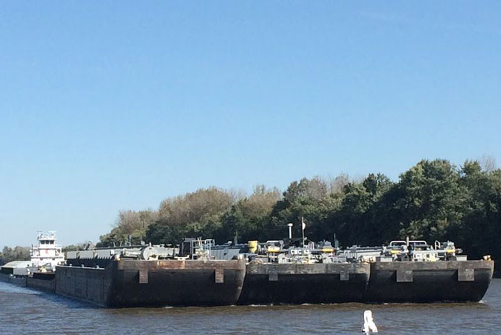
Despite all of that, why do I believe it’s a mistake to rush through this section? Simple – it’s the heartland of America. It’s where blue collar meets no collar. Where the people say “bless your heart” and offer you sweet tea. It’s where you marvel at the jaw-dropping skill of tow captains pushing 48 barges upstream in seven knots of current. It makes you realize the ingenuity of the American spirit and what it must have been like for traders, trappers, loggers, Native Americans, and fisherman who traveled those waters as they built the foundation of our country.
To sum it up, the Mississippi waters will make you proud of your country and the wholesome, real people who make that leg of the journey so amazing. So, for those of you looking find your inner Jack Kerouac through the heart of America, here are some basic tips, not-to-miss stops, and insider information that will help make your journey memorable.
General Information
From Chicago, Illinois to Mobile, Alabama, you’ll travel roughly 1,300 miles down more than six different waterways and encounter 22 or more locks, all of which are free of charge. With the exception of the Ohio, Tennessee, and Cumberland Rivers, all of the rivers flow at various speeds to the south.
The rivers can be a hazardous place with large floating debris coupled with heavy barge and commercial traffic. Commercial traffic on the river system always has the right-of-way, and pleasure craft needs to be diligent about communicating with the tow captains and leaving them plenty of space to safely navigate. It is not advisable to travel at night – navigational buoys are unlit, and hazards in the water can severely damage even the largest vessels.
There are two sources of information that I recommend using daily to help you make your way south. The first is Cruising from Chicago to Mobile. It’s cost effective at just $16, and I found it to be fairly reliable (however, I recommend checking a few sources or calling ahead to double check reported depths). The second source is an on-line platform called Active Captain. Active Captain is a free, interactive cruising guidebook that allows boaters to post information, review anchorages and marinas, document fuel prices, etc. It is especially handy for boaters who prefer to anchor out as much as possible.
The river systems and marinas along your route are very shallow and are constantly being dredged. If you draft more than three feet get towing insurance because, at some point, you will run aground. Let me repeat: you will run aground. Tow Boat US and Sea Tow are reliable companies that offer unlimited towing packages for less than a couple hundred dollars per year.
Chicago and the Illinois River
If you’re in a sailboat, you’ll need to lower your mast in the Chicago area. Most boats travel down Lake Michigan to the Calumet River, just south of Chicago, to have one of the many boat yards complete the service. Once you’re under power, you have to make your first decision.
To get to the Illinois River, you can continue down Calumet River and go through the T. J. O’Brien Lock and Dam, or you can travel back north to Chicago and go through the Chicago Harbor Lock. If you choose the later, you’ll travel right through one of America’s greatest cities. (I recommend the second option.)
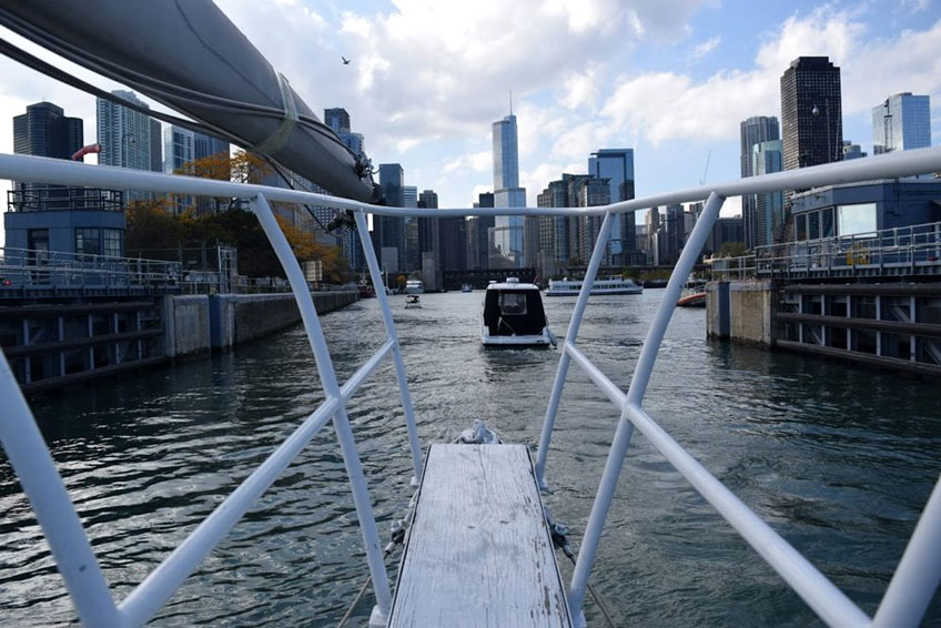
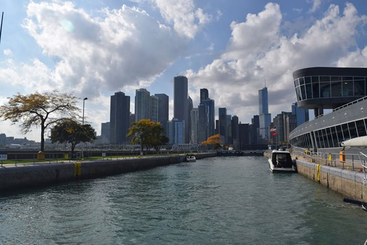 Chicago Harbor Lock
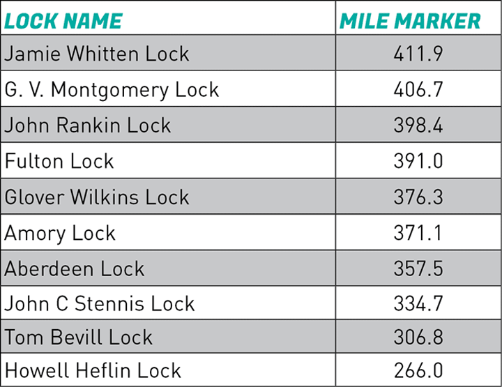
As you approach the lock, be sure to put on your life jacket (required by the Army Corps of Engineers), ready your lines and fenders, and radio the lock master to await instructions. The Chicago Harbor Lock is the second-busiest lock in the nation for recreational use, so be sure that you’re paying attention and not causing delays. (Over the next few days you’ll travel through the series of locks included in Table One. You’ll follow these steps every time you approach a lock.)
Once you’re through the lock, you’ll enter the Chicago Sanitary and Ship Canal before you meet with the Des Plaines River. The canal travels for several miles, winding through the busiest parts of the city. Enjoy it. It’s one of the most exciting and picturesque parts of the trip.
The hustle and bustle of the city fades away surprisingly quickly as you enter the Illinois River. Large, industrial complexes and mile-high skyscrapers give way to the peaceful river.
Some notable stops along the way included Ottawa, Illinois and Starved Rock State Park.
Ottawa, Illinois provides a well-maintained, free dock. It’s a short walk to the grocery store, bike shop, walking trails, restaurants, a fabulous cheese shop, and a YMCA.
Starved Rock State Park is a great place to pull over and stretch your legs. The site has steep sandstone cliffs, countless waterfalls, and miles of hiking trails. It’s consistently ranked as Illinois’s #1 tourist destination. Finding a safe place to anchor is a bit of a challenge. Depending on the size of your boat and the season, the lock master may give you permission to tie up outside the lock.
The Illinois and Mississippi rivers collide in Grafton, Illinois, where you’ll find the Loading Dock Bar and Restaurant. It’s worthwhile to stop there if you can, but beware of the docking. The free dock is actually a rusty, steel wall that’s completely exposed to the relentless wake of boating traffic. With no ladder and just a few industrial-sized cleats left over from when it was a boat-building company a century ago, it can be hazardous if you’re not prepared.
The Loading Dock is usually packed with motorcycles and classic cars, and it features decent concerts and special events, like car shows, flea markets, and hoedowns. The food is nothing special, but the people watching is spectacular. There are plenty of trinket shops and old-style ice cream parlors, a fruit stand, fish market, and a small convenience store within walking distance of the dock. Like many of the small towns you’ll encounter, their hours come-and-go like the cars driving the scenic highway.
Mississippi River
The most treacherous part of your trip, the Mississippi River has the heaviest commercial traffic coupled with the strongest currents which can make for dangerous situations. Be sure that your engine is running properly and that you and your crew have a backup plan in case you experience an engine failure. You’ll travel 221.5 miles down the Middle Mississippi, a relatively free-flowing section from Grafton, Illinois to the Ohio River in Cairo, Illinois.
At mile marker 212 is the Our Lady of the Rivers shrine, which honors the 41 people who perished in a horrific flood in July 1951. Shortly after that you’ll go through the Melvin Price Lock and Dam at 200.8 miles and the Chain of Rocks Lock at mile marker 185.
Once you’re through both locks, you’ll come to St. Louis, Missouri, the second largest city on your trip. After going under the Martin Luther King Bridge, you’ll see the St. Louis Gateway Arch to the west. There are no marinas or places to stop within walking distance to the arch, so be mindful of the commercial traffic and go slow so you can get a good photo from your boat.
At mile marker 158.5 is the legendary Hoppies Marina. Owners Fern and Hoppy are real river rats. Since opening their marina in the 1950s, it doesn’t seem like much has changed. The marina consists of a couple of rusty old barges you can tie to, along with potable water and fuel. There are no bathrooms, but there is a courtesy car that you can drive the 15 minutes into town to get provisions. Every evening Fern gathers the boaters around for 45 minutes of tips, updates, and conditions for the next couple of hundred miles. It’s something you won’t want to miss. Hoppies is the last reliable stop for fuel and facilities along the river until you reach Kentucky Lake, about 230 miles away, so be sure to plan accordingly.
About 110 miles further downriver is the Little Diversion Channel (at mile marker 48.8). This well-known stop provides a deep-water sanctuary for boaters seeking refuge from the barges and their wake. There are usually several boats anchored there for the night. It’s the perfect place to meet new friends over sundowners while planning your approach to the next river – the Ohio River.
I recommend traveling down the Ohio River and out to Mobile Bay in Alabama. If you choose to stay on the Mississippi, you’ll travel down the Lower Mississippi all the way to the Mississippi River Delta in southern Louisiana, eventually meeting the Gulf of Mexico in New Orleans.
Ohio and Cumberland Rivers
The Ohio River is the first river where you’ll battle against the current. The 46-mile stretch from Cairo, Illinois to Paducah, Kentucky is just the beginning.
At mile marker 964.8, you’ll encounter an engineering marvel – construction of the new Olmsted Lock and Dam. Slated to open in 2018, you may have to follow an escort through the construction area, depending on conditions. The busiest lock in the American Inland waterways, the Olmsted Lock and Dam will replace lock and dams 53 and 52 and will help alleviate congestion and wait times.
Another safe haven is just north of Metropolis at mile marker 953.3. The Bean Branch Creek rest stop provides 18-foot depths and has enough room for three of four boats to anchor for the night. There is a public boat ramp inside of the creek, but no facilities.
Once you reach Paducah, you’ll have to decide again which direction to go. If you’re a gambling man, you can throw caution to the wind and head up the Tennessee River to the Kentucky Lock, 20 miles to the east. It’s a shorter route, but beware – boaters often report notoriously long wait times, sometimes in excess of eight hours, to get through the lock. Your second option is to stay the course on the Ohio River until it meets with the Cumberland River in Smithland, Kentucky, then follow it all the way until you reach the Barkley Lock. Both routes more or less converge at the Land Between the Lakes, a 170,000-acre national recreational area.
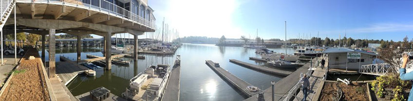 Green Turtle Bay
Situated a few miles from either of those routes is the Green Turtle Bay Marina in Grand Rivers, Kentucky. It’s the largest, full-service marina between Chicago and Mobile Bay, and it’s close to half way between the two. It’s a great place to get work done on your boat, attend to your land-based affairs, or just rest, relax, and re-energize for the second half of your trip. There’s a courtesy car, spa, restaurant, yacht club, ship store, laundry facilities, pool, and gym all at your disposal. Libations are not available, however, because the marina and resort are in a dry county.
Grand Rivers is within walking distance of the marina. The biggest attraction there is Patty’s Restaurant. The acclaimed eatery is in a recreated Kentucky log cabin and serves a two-inch pork chop, its signature dish. In addition to its charm and fantastic food, Grand Rivers also boasts the largest Christmas-light display in Kentucky on the sprawling grounds behind the restaurant.
Once you depart Grand Rivers, you’ll be on Kentucky Lake. Created in 1944 by the building of the Kentucky Dam, the 160,000-acre lake is the largest man-made lake in the eastern United States.
Tennessee River
As Kentucky Lake narrows at the southern end near New Johnsonville, you’ll find yourself on the Tennessee River. Once called the Cherokee River, this 214-mile stretch will be the last leg of your journey fighting against the current. Featuring beautiful sandstone cliffs along its banks, the only lock you’ll encounter, if you’re heading to the Tennessee Tombigbee Waterway, is the Pickwick Lock and Dam at mile marker 207.
You’ll have lots of options for staying overnight. Pebble Isle Harbor in Johnsonville, Kentucky offers an excellent facility at the dock or anchoring in a protected cove off the river. Past the lock are Red Sulfer Springs, Mississippi, a beautiful place to stay the night, and the Aqua Yacht Harbor and Grand Harbor Marina, who both accept transient boaters. My recommendation, however, is to pick one of the half-dozen southern fingers and enjoy a peaceful anchorage among nature.
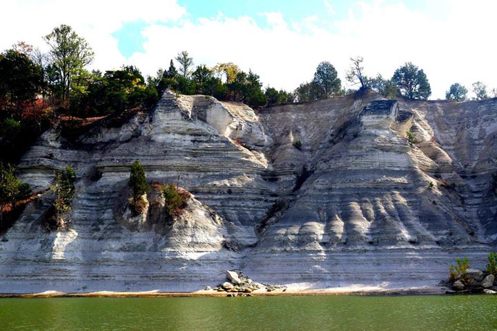 Tennessee River Cliffs
Once you pass through Pickwick, you can take a popular detour and stay on the Tennessee River through seven more locks on your way to Chattanooga and Knoxville. This linear detour is a little more than 350 miles each way.
Tennessee-Tombigbee Waterway
The last major leg of your journey, and your reprieve to chugging along against the current, is the Tennessee-Tombigbee Waterway.
The Tennessee-Tombigbee Waterway, or Tenn-Tom for short, is an accomplishment of American ingenuity and resolve. The 234-mile canal was a colossal undertaking, and the earth literally moved to build the waterway – it was the largest earth-moving project in the history of mankind, with 310 million cubic yards of soil moved. Ten locks and dams control the elevations and water flow, lowering a total of 341 feet along your journey.
Roughly eight miles north of Gainesville, Alabama, you’ll find the Warsaw Cutoff, an excellent deep-water anchorage. The anchorage is fairly deep, so be sure to hug the north shore for shallower depths, or put out plenty of scope. Another excellent anchorage is Bashi Creek at mile marker 145. Although the creek looks too narrow to dare, I anchored there with ease with several other large boats. The creek is fairly deep for several hundred feet and provides excellent holding with minimal wake.
Don’t pass up the opportunity to stop in Coffeeville, Alabama to visit Bobby’s Fish Camp. Bobby’s is one of the oldest continually-operated restaurants in southwest Alabama, and it serves the best fired catfish I have ever eaten. Going to Bobby’s is like stepping back into river history. Every inch is filled with artifacts, trinkets, and memories of a by-gone era. There are river monsters on the walls, signed photos of guests (famous and ordinary alike), and an impressive Coca-Cola collection. The food is southern, the fish is fresh, and the ladies who run it are simply delightful. Technically the restaurant is only open Thursday through Saturday, but they’ve been known to make an exception if you call ahead.
Your last stop before reaching Mobile Bay will be an anchorage on the Tensaw River where it splits from the Mobile River. The small-boat traffic there is fairly heavy during the evening, but at night the waters are relatively calm and provide a nice, peaceful setting where you can mentally prepare for the hustle and bustle of Mobile Bay.
If you’re like me, you’ll find yourself sitting on deck and staring quietly in front of your vessel throughout your trip. With each turn of the massive rivers, you’ll find yourself appreciating what they have to offer the common traveler. The vistas are not particularly breathtaking, the boating not particularly relaxing, but they’re a part of the journey. Those rivers fueled the dreams of our forefathers, and they are there for you to discover and enjoy in all of their glory.